
Friday, December 27, 2013
Wednesday, December 25, 2013: Christmas Day! Blue skies with temperatures in the low 30s. Diane Manas led a small group on a refreshing hike along the 4.5 mile Mossy Ridge Trail in Percy Warner Park - Nashville. Hikers (left to right): Diane Manas, Bob Franz, Nancy Zambito, Carol Smith, Dianna Richter, and Doug Burroughs. This time of year, one or more anonymous elves decorate cedar trees along the way with a few ornaments: Shiny ones and a few replicas of the owls that reside in the park.

Thursday, December 19, 2013
Nashville TTA Chapter Raises over $500 for the Cumberland Trail
Saturday, December 14, 2013, Brentwood TN: Organized by Amy Sutton, eleven different volunteers spent from two to over eight hours at the gift wrapping station at REI. Shoppers were offered the opportunity to have their gifts wrapped by one of our volunteers in exchange for a donation. Many thanks to the following volunteers: Amy Blanton, Kathryn Skinner, Doug Burroughs, Dianna Richter, Nora Beck, Sue Biggers, Betty Magee, Tom Vickstrom, Julie Walski, and June Parker. The money donated will be used to help feed the volunteers at the next Cumberland Trail Spring Breakaway.


Wednesday, August 21, 2013
On Saturday August 17, 2013, seven hikers met at the new Cummins Falls State Park parking lot (complete with new restroom) and took in the beautiful sights of the Cummins Falls. We walked to the overlook first to catch a glimpse of what was to come and then walked the next 1/2 mile downhill to the creek. The rest of the 1/2 mile walk upstream was a challenging rock hop and wade up to the plunge pool of the falls where some of us took a cooling (freezing) dip. We ate our lunch here and relaxed, watching the swimmers, jumpers and climbers on the falls. It was a beautiful, cool August day for hiking and swimming, and a short pleasant drive from Nashville. This park is a hop, skip and a jump, ( literally) and easily accessible to all.


Friday, May 10, 2013
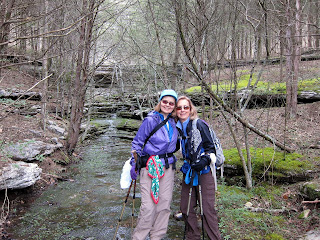
FOOTHILLS TRAIL: APRIL 20-27, 2013
Three
backpackers from Nashville (Karl, Ed & Diane) and one from North
Georgia (Dwight) just completed a TTA outing backpacking The
Foothills Trail in South Carolina.
A
little bit about The Foothills Trail . . . . The Foothills Trail is
about 77 miles in length; located along the Blue Ridge Escarpment in
Upstate South Carolina and Western North Carolina; and, offers an
extraordinary opportunity to explore the Southern Appalachians. The
landscape is diverse, ranging from high rocky outcrops with views to
the distant horizon, to quiet forests in deep valleys carved by bold
mountain streams. Elevations along The Foothills Trail range from
1,120 feet at Table Rock State Park to 3,560 feet atop Sassafras
Mountain. The Foothills Trail is rather rugged and often in remote
wilderness areas with little to no outside access. Although the word
"Foothills" makes one think of small rolling hills, that
was not the case! There were tall, rocky, and steep mountains –
and, definitely not a casual stroll in the forest. Because The
Foothills Trail is a linear trail, and not a loop hike, in order to
traverse the entire trail one must arrange to have a car at both ends
or locate a shuttle to provide transportation to one end of the
trail.
We
met at the Table Rock State Park in Pickens South Carolina (SC) on
Saturday April 20; dropped a car, and were met shortly thereafter by
their shuttle driver (Heyward) and transported to the most western
end of the trail in Oconee State Park in Mountain Rest, SC to begin
their easterly traversing backpacking trip. Daily mileage ranged
between 10-14 miles. The backpacking trip ended the following
Saturday April 27.
The
weather was perfect; sunny or partly cloudy – daytime temps were in
the low to mid 60s; nighttime temps in the low to mid 40s. One day
may have reached 70 degrees. We couldn’t see a whole lot of stars
due to the moon’s size and bright beam cast each night over the 7
nights out. We did have one evening mid-week of intermittent
sprinkles but they were soon pushed out by a northerly breeze that
dried our tents before daylight. The last night out we had rain which
began after dark and was an off and on rain through the early morning
but stopped during the time we were breaking camp. The rain held off
for the duration of our hike, and only began again just after our
reaching Table Rock State Park and our cars. Then it began again –
this time a non-stop rain which lasted all the way home! Really, not
a bad trade-off.
The trail was in excellent shape – wide in some places; nothing encroaching or over growing on the trail. Sure there were the usual trail challenges from roots, rocks, mud, and hills but there were also a lot of wooden steps on the steepest of descents and ascents, beautifully designed bridges (no streams to ford) and lots of fragrant pine needles to carpet the trail and soften the walking. We walked along beautiful rivers and streams; some raging while others gently flowing; all of which ran very clear with minimal sediment, dirt or floaters; and through many rhododendron tunnels.
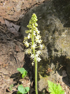
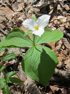
We saw the last petal or two of the Oconee Bells; however, there were many more wildflowers equally enjoyed – Dwarf-crested Iris and Foam Flower was visibly lining many portions of the trail; there was fragrant Pinxter Azalea and Dog hobble; also seen were Gay Wings (Polygala); Showy Orchis; white, pink and burgundy colored Trillium; Solomon’s Seal; False Solomon Seal; Rue Anemone; Wild Oats; and many more.
We didn’t see very much in the way of wildlife; outside of 3 snakes, 2 lizards, 2 orange salamanders, and a couple of wild turkeys. We saw 1 squirrel and nothing in the way of bears, deer or ground critters. We saw in only one area the ground torn up by wild hogs “rooting” for stuff to eat.
All of the designated campsite areas were well cared for and evidence of Leave No Trace were adhered to. But the ones that we found trash in we burned the rubbish. At one site we found and burned up a soccer ball, a flip-flop shoe and a Katadyn water filter cartridge. Since the area is not heavily traveled finding firewood was fairly easy.
We ran into a large group of, I’ll call them retired people, as they appeared to be in their mid to late 60s; maybe even older; comprised of 2 or 3 women and about 6 men; they had started from Sassafras Mtn and were heading to Oconee SP. They appeared to be strong hikers but commented to me that the westerly to easterly direction we chose to backpack was the direction to go. We also ran into a couple of solo backpackers wishing they had chosen the same direction we were traveling. Traveling from east to west; i.e., from Table Rock to Oconee; is the strenuous direction due to the elevation climbed over the first day and a half. By traveling west to east the elevation is climbed over the last couple of days, when one’s legs are stronger and the least amount of food in your backpack.
The trail was beautiful; the sights along the way were far greater than I had imagined; and the joy obtain through backpacking with a great group of people have imprinted memories that will last a lifetime. If you have ever thought about backpacking the Foothills Trail, get your gear together and go!

Four hikers with shuttle driver.

Chatooga River

Steps

Rhododendron Tunnel

Waterfall

NC SC Border

Lake Jocassee

Whitewater River

Bridge

Artsy Bridge

Karl teaching macrame

View
Saturday, April 20, 2013


Saturday, April 13, 2013: A small group from the Nashville Chapter drove down to Monteagle TN in the morning and attended several Trails & Trilliums events sponsored by the Friends of the South Cumberland State Park. First was a ramble for an hour and a half around the grounds of the Monteagle Methodist Assembly with David Haskell, author of The Forest Unseen. Then, we hiked for about two hours in Shakerag Hollow, which is where the photos below were taken. After a fine dinner at Mi Casa, we attended the Trails & Trilliums Wine & Cheese Reception and heard David Haskell speak again.


Monday, March 18, 2013
On
Sunday, March 17, 2013, nine hikers gathered for a tour of the
Mississippian Period Indian Mound Complex known as Mound Bottom,
located on a private area of the Harpeth River State Park. The
ranger was very informative and knowledgeable about the area. After
walking the Mound Bottom area, the group proceeded to the Mace
Bluff across
the Harpeth River from the Mounds to see them from afar as well as to
see the Mace Petroglyph.
.jpg)
.jpg)
.jpg)
.jpg)
.jpg)
.jpg)
Sunday, March 10, 2013
On March 9th, ten hikers from Nashville set out on full day excursion to explore the sights along the Natchez Trace Parkway and surrounding area. Our first stop of the day was at the Historic Gordon House, a short 1/2 mile walk to view the site of the old ferry crossing of the Duck River, got us loosened up. Next stop was the beautiful Jackson Falls where we were able to spot a few early wildflowers, namely Saxifrage, growing among the rocks along the falls. The last stop along the Trace was to hike the 3 mile Devil's Backbone Loop. No wildflowers were spotted on this trail, but it was a very pleasant winter woods walk up and down the "backbone". We then drove about 15 miles and had a delicious lunch at the very pleasant Mt Pleasant Grille. From there we made our last stop at Stillhouse Hollow Falls, and we admired the trail and bridgework that the Columbia Chapter had helped to build, besides admiring the falls! The wildflowers were more abundant around the falls and we spotted, Cutleaf Toothwort, Anenome, Hepatica and some Harbinger of Spring.


Sunday, February 24, 2013
Saturday, February 23rd: A small group of three hikers from Nashville TTA spent a pleasant day hiking the 5.5 mile length of the Bearwaller Gap Trail near Carthage Tennessee. From the Defeated Creek trailhead, once we got over the first knob and down the steep downhill trail bed on the other side, the trail bed itself was not an issue. We wound around coves, across streams, and over ridges close to but high above the shoreline of Cordell Hull Lake. Many of the streambeds that had been dry a few days before when the trail was scouted were now, due to the recent rain, flowing well. With the leaves off the trees, we had excellent views to the lake and through the open forest. The hike started off cool and overcast but the sun was out and we were much warmer by the time we finished the uphill climb the ends the trail at the Tater Knob Overlook.


Thursday, February 21, 2013
On February 16, six hikers from Nashville drove 2 hours to Nathan Bedford Forrest State Park in Eva TN. It is a lovely park perched above the Tennessee River/Kentucky Lake. The temperatures were in the 40s which the intermittent sun helped to feel more like the 50s. The trail system in this park is organized into 4 interconnecting loops of 3. 5, 10 and 20 miles. The loops were very well blazed and signed. We were also provided with a color coded trail map. It was very easy for hikers in the group to chose either the 5 or 10 mile loop and meet back at the starting place which was the interesting Tennessee River Folklife Center. Both hiking groups were finished before 2:00, leaving plenty of time to view two very interesting movies at the Center and explore the exhibits. Later some hikers partook of the abundant antique decor and catfish at the 1850's Log House Restaurant in Camden. It was a great day for a winter hike with wonderful views of the river and no bugs!


Subscribe to:
Posts (Atom)