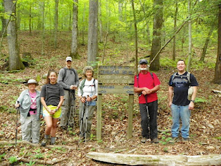
Tuesday, May 22, 2012: The Nashville Chapter held it's annual picnic at Percy Warner Park in Nashville. The potluck items included a free pan of Vera Churcher's brownies. The meal was followed by a two mile walk on the loop road in the park.
Blog of the Nashville Chapter of Tennessee Trails Association. Monthly Meeting: 4th Tuesday - 7 PM - REI Brentwood.
Thursday, May 24, 2012
Tuesday, May 15, 2012
On Friday, May 11, 2012: Nine people
left Nashville and Maryville for Frozen Head State Park. It was
to be a fabulous car camping weekend. Campers included were:
Garnett Rush, Nancy Juodenas, Jerry Hendrixson, Libby Francis, Betty
Magee and her son Chris, Larry Marchese and his wife Erica and
daughter Anna. Friday was spent setting up camp and then a
short warm-up hike on the Judge Branch Trail. Saturday we were
met at the trailhead by Bill Taber from Nashville. We hiked up
the lovely Panther Branch Trail, walking along a creek bed,
passing a waterfall, spotting a few late spring wildflowers, and some
interesting rock formations. After about 2.5 miles we merged
with the North Old Mac Trail which continued up the mountain.
Upon reaching Panther Gap and the junction with the jeep road we took
a spur trail to see Panther Cave, where there is a back country
campsite. After eating lunch at the Tub Springs campsite, we
climbed the road to the old fire tower and were rewarded with the
skies clearing for some beautiful panoramic views of the valley
ridges and mountains to the east, and south. For the return
trip we took the shorter South Old Mac Trail. Sunday we had
plans to hike a section of the Cumberland Trail, but woke up to rain.
So, after some breakfast and socializing we packed up and said our
goodbyes. Frozen Head State Park is a sweet pocket of mountains and
forest near tiny Wartburg TN. It was well worth the 2-3 hour
trip for a fine weekend of hiking and camping.
Thursday, May 10, 2012
Smokies
Backpack – April 25-29, 2012
Wednesday,
April 25, 2012
Hike
Leader, Diane Manas, with hikers Garnett Rush, Tom Vickstrom, Amy
Sutton. Parked at Cades Cove and got a shuttle ride to the
Clingman’s Dome. Hiked to Double Spring Gap Shelter. the first
night. We met numerous AT through hikers, including one person
mapping the trail with GPS.
Thursday,
April 26
The
morning started with a heavy hailstorm that we watched from the
safety of the shelter. We waited a while then commenced hiking in
light rain. We hiked 1 mile on the AT to Welch Ridge Trail, then
descended to Hazel Creek Trail to campsite #82 for the night (9.5
miles, total day). We observed the transition from bare trees amidst
spruce and hemlock at high elevations to budding trees as the forest
greeted springtime’s gradual onset. We also witnessed Garnett
majestically topple onto her backpack while resting on a rotten
stump, and the trail name “Turtle” was awarded. Down below
things gradually leveled out. On the Hazel Creek Trail we had 22
creek crossings – yes 22! We saw a bear at one point, but he took
off running when he noticed us. Our campsite was spacious and close
to the creek. About 4 pm, just after we’d set up tents, the skies
opened up with a terrific hailstorm and about an hour of heavy rain.
The creek turned a raging brown torrent. We had some puddles at our
tents and several tents were relocated. It drizzled during the
night, but cleared long enough for us to cook supper.
Friday,
April 27
We
hiked Hazel Creek Trail to Bone Valley and hung up our gear to dry
near a campsite. Then, with lighter loads, walked up the Bone Valley
Trail & back. It was worth the hike – there’s a really well
preserved dwelling named Hall Cabin there, built in 1880. We ate
lunch there on the front porch with four trout fishermen who reported
they’d seen three wild pigs down by the creek. We had four or five
creek crossing each way on this side trip, and the water was swift
and high. We returned to the Hazel Creek Trail and followed about a
mile to campsite #84 for the night. (7.3 miles total for the day).
Saturday,
April 28
Uphill
all the way! With an early start we hiked up Jenkins Ridge Trail to
the AT, an elevation gain of approximately 2,900 feet. There were
three steep sections with few switchbacks and it was a steady uphill
trek all day. We admired many beautiful wildflowers, including
Bluets, Painted and Vaseys Trillium, Yellow Stargrass, and Dwarf
Crested Iris. The weather was clear and pleasant. At the ridge, we
followed the AT for a short ways to Spence Field Shelter. (9 miles
total for the day). There were a dozen or more through hikers here,
including two who cruised in late after doing 28 miles that day.
Sunday,
April 29
It’s
was “downhill all the way” back to our car via Bote Mountain
Trail and Anthony Creek Trail. (5.3 miles). Stony trail, a little
rough on the feet – at least Tom thought so. We exited the park
and made our way to Tomato Head restaurant in Maryville – an
outstanding place!
Subscribe to:
Comments (Atom)


